Why Coastal Louisiana Has Lost 1,900 Square Miles of Land Since the 1930s
Louisiana’s coast has vanished at an unprecedented rate, with 1,900 square miles lost since 1930 due to human activity, climate change, and land subsidence.

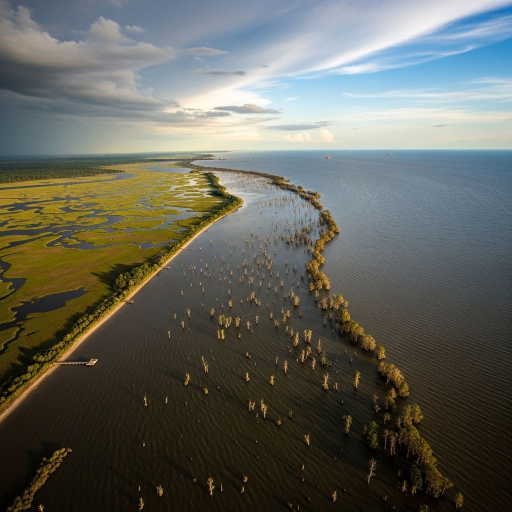
Louisiana’s coast has long been a landscape of marshes, swamps, and barrier islands—dynamic habitats forged between fresh and saltwater, river and gulf. Yet in the last century, this intricate system has suffered one of the gravest land loss crises in the United States. Since the 1930s, nearly 1,900 square miles of coastal land have disappeared, an area roughly the size of Delaware. This vanishing shore poses threats not just to wildlife, but also to human communities, economies, and the fabric of coastal life itself.
How Much Land Has Been Lost?
Between 1932 and 2016, coastal Louisiana experienced a net loss of approximately 4,833 square kilometers (1,900 square miles). This equates to a 25% reduction of the 1932 land area. Every year, 25–35 square miles of coastal terrain vanish into the water—about a football field every 100 minutes.
| Time Period | Land Lost (sq miles) | Percentage Loss |
|---|---|---|
| 1932–2016 | ~1,900 | ~25% |
| Projected Next 50 Years | Up to 4,120 | — |
Major Causes of Land Loss
The reasons behind Louisiana’s disappearing coast are multifaceted, resulting from a combination of human interventions and natural processes.
1. Leveeing the Mississippi River
Powerful levees line the Mississippi River, built to protect communities and infrastructures from floods. However, this has cut the river’s natural connection to its delta, halting the cycle of sediment deposition that historically built and restored wetlands. Now, instead of replenishing local marshes, sediment shoots out the river’s mouth and ends up wasted in the Gulf of Mexico.
- Wetlands require river sediment to grow and survive.
- Levees mean sediment bypasses the delta marshes, accelerating erosion.
- Lack of replenishment renders the wetlands vulnerable to subsidence and rising seas.
2. Shipping Channels and Canals
Lousiana’s waterways are crisscrossed with shipping channels—MRGO (Mississippi River Gulf Outlet), the Houma Navigational Canal, and the Freshwater Bayou Canal are just a few. These channels allow saltwater to penetrate deep into freshwater marshes, disrupting the delicate balance needed for marsh plants to survive.
- Saltwater intrusion kills vegetation adapted to freshwater, destabilizing marsh soil.
- Channels act as conduits for erosion and land fragmentation.
3. Oil and Gas Infrastructure
As America’s Energy Coast, Louisiana is covered with thousands of offshore oil rigs, onshore wells, and an extensive network of pipelines. The construction and maintenance of these infrastructures dredged thousands of miles of canals through wetlands, altering hydrology, changing salinity levels, and often destroying habitats.
- Pipelines and canals disrupt the natural water flow, leading to increased subsidence and loss of vegetation.
- Oil and gas exploration sometimes causes direct physical damage to marshes and swamps.
4. Subsidence
Subsidence refers to the sinking of land, caused by both natural geological processes and human activities. Louisiana’s delta soils settle and compact naturally, but the situation is worsened when sediment is no longer supplied by the river.
- Land elevation drops as underlying sediments compact over time.
- Oil and gas extraction further accelerates subsidence in affected areas.
- Subsidence amplifies the impact of rising sea levels, turning marsh into open water faster.
5. Sea Level Rise and Climate Change
Relative sea level in Southeast Louisiana is rising at a rate of about three feet per hundred years. This includes both global ocean rise and local land subsidence.
- Inundation of marshes and swamps occurs as water levels overtake sinking land.
- Marshes that cannot build up with new sediment become permanent open water.
- Climate change is likely to accelerate both sea level rise and extreme weather events, intensifying erosion.
Impacts of Coastal Land Loss
Environmental Impacts
- Loss of crucial habitats for fish, birds, and wildlife—including migratory birds and endangered species.
- Reduction in the natural storm protection provided by wetlands, marshes, and barrier islands.
- Disruption of the nutrient and sediment cycles vital for coastal ecosystem health.
Community and Economic Consequences
- Increased vulnerability for coastal communities to flooding and storms.
- Threats to infrastructure, including highways, ports, and energy facilities.
- Impact on commercial and recreational fisheries, a pillar of Louisiana’s economy.
- Loss of cultural heritage for Indigenous and local communities that rely on the land.
Visualizing Land Loss: Satellite and Historical Perspectives
NASA satellite imagery and historical surveys illustrate the extent of land area change. Comparing the 1932 coastline to modern images shows dramatic conversion of marshland into open water.
- 1932: Expansive marshes, swamps, and barrier islands present.
- 2011: Significant areas replaced by open water; new land primarily results from engineered shoreline improvements.
Efforts to Restore and Protect the Coast
Recognizing the urgency, Louisiana has crafted a coastal master plan that aims to restore wetlands and protect communities. However, the scale of the loss requires huge volumes of sediment—an estimated 5 to 11 billion cubic meters over the coming decades.
- Projects investigate sources and composition of sediment for targeted restoration.
- Innovative approaches include diverting river water back into marsh areas and developing living shorelines.
- Collaboration among local, state, federal agencies, and academic researchers is ongoing.
A Closer Look: The Science Behind the Sinking Coast
Wetland Formation and Sediment Dynamics
Louisiana’s coastal landscape was historically created by cycles of flooding and sediment deposition. River flooding would deliver vital nutrients and new soil, building up marshes layer by layer. When this process is interrupted or redirected, marshes starve for sediment and disappear.
Subsidence Explained
Subsidence is driven by several mechanisms:
- Soil Compaction: As marsh soils dry out or lose vegetation, they compress.
- Fluid Withdrawal: Oil and gas production often involves pumping subsurface fluids, lower pressure and accelerating sinkage.
- Lack of Sediment: Marshes can’t keep pace with subsidence without new soils from the river.
Future Outlook: Will Louisiana Lose More Land?
Without substantial intervention, projections suggest Louisiana could lose an additional 4,000+ square miles of coastal land in the next 50 years.
- Accelerating climate change likely to worsen storm surges and sea level rise.
- Barriers to restoration include technical challenges, funding, and political will.
Frequently Asked Questions (FAQs)
How fast is Louisiana losing land?
On average, Louisiana loses one football field worth of wetlands every 100 minutes. Annual losses range from 25 to 35 square miles.
What’s destroying the coastline—nature or people?
While natural processes like subsidence and tidal changes play a role, human activities—including levees, canals, and oil/gas extraction—have greatly accelerated the loss.
Can the lost land ever be restored?
Some restoration is possible using dredged sediment, river diversions, and engineered solutions, but reversing decades of decline is challenging and requires sustained investment.
Why is land loss a problem for people?
Losing marshes and barrier islands exposes communities to flooding and storms, damages fisheries, and threatens jobs and cultures connected to the coast.
What is being done to save the coastline?
The Louisiana Coastal Master Plan guides efforts to restore land via sediment diversions, marsh creation, and shoreline improvements. Researchers continue to search for suitable sediment and restoration strategies.
Key Takeaways
- Louisiana’s coast has lost nearly 1,900 square miles of land since the 1930s—a crisis propelled by levees, canals, oil/gas activity, subsidence, and rising seas.
- This loss jeopardizes communities, infrastructure, wildlife, and the unique cultural fabric of coastal Louisiana.
- Restoration plans are underway, but require massive resources and coordinated action.
References
- https://www.vanishingparadise.org/coastal-land-loss-po/major-factors-for-louisianas-land-loss/
- https://pubs.usgs.gov/sim/3381/sim3381_pamphlet.pdf
- https://www.climate.gov/news-features/featured-images/underwater-land-loss-coastal-louisiana-1932
- https://mississippiriverdelta.org/our-coastal-crisis/land-loss/
- https://www.uno.edu/news/2022-05-02/earth-and-environmental-sciences-prof-mark-kulps-research-aids-louisianas-coastal-restoration
- https://en.wikipedia.org/wiki/Coastal_erosion_in_Louisiana
- https://mississippiriverdelta.org/whats-at-stake/people/
- https://www.lacoast.gov/landloss/2050_2R_missbig.pdf
Read full bio of medha deb


